Using Mobility Data to Improve Lives in Lima
Improving traffic flow and enhancing road safety are critical to Lima which was ranked the fourth most congested metropolitan area in the world in 2022.
Assessing Traffic Congestion and Accessibility to Jobs Using Waze for Cities and Mapbox Data
Traffic congestion and suburbanization are becoming increasingly significant factors affecting urban mobility and limiting access to jobs and opportunities in most mid-sized cities worldwide.
Insights from Leveraging Big Data to Track the Impact of the COVID-19 Pandemic on Mobility in Buenos Aires
How did the COVID-19 pandemic and the lockdown measures affect mobility in cities around the globe?
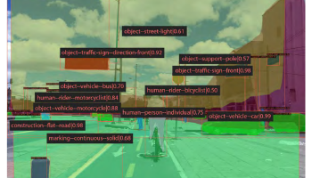
How Big Data and Machine Learning Can Strengthen Road Safety
High-quality and reliable data is necessary to gain useful, actionable insights and enhance road safety conditions.
The Effects of City Growth on Traffic and Urban Mobility
The Romanian city of Cluj-Napoca has been deeply affected by urban sprawl, which has strained the city’s traffic system and caused increased congestion on roadways.
Buenos Aires Transport Demand Planning
Challenge The COVID-19 pandemic and the lockdown measures implemented in 2020 had a significant impact on mobility in the Metropolitan Area of Buenos Aires (AMBA), adding new constrains to the travel behaviours of residents and businesses.
A Data-Driven Framework to Support Bogota’s Barrios Vitales Project
A data-driven framework to support the design, implementation, and evaluation of a superblock model in Bogotá from a speed management perspective and inform street design alternatives in the urban space.
Visualizing Millions of Waze Traffic Alerts with BigQuery, H3 and Dask
Waze for Cities, a Data Partner of the Development Data Partnership, connects government partners to high quality, frequent and granular traffic data extremely valuable in informing public sector, transport and urban planning as well as addressing the United Nations’s Sustainable Development Goals.
Improving Road Safety in Nairobi
“Data Partnership brings domain expertise. Google brings data expertise. Together we impact real world problems.”